|
1995年4月25日云南省金平5.5级地震
云南省地震局 李永莉 唐 采 曹 刻
摘要 |
前言 | 测震台网及基本参数 |
地震地质背景 | 烈度分布及震害 |
地震序列 | 震源机制解和主破裂面
观测台网及前兆异常 | 总结与讨论 |
参考文献和参考资料
摘 要
1995年4月25日云南省金平县发生MS5.5级地震,地震宏观震中位于金平县者米乡晖家寨与顶青之间,极震区烈度为Ⅶ度,极震区为北西向椭圆,地震发生在红河-哀牢山深大断裂带南侧南段的藤条江断裂以西地区。地震无人员死亡,伤20人:其中重伤3人,轻伤17人;经济损失达1100万元人民币。
地震序列为孤立型,序列最大余震为ML2.6级,余震衰减较快。余震区长轴近北西向,震源机制解中节面Ⅱ走向北北西,Ρ轴方向北西西,推测地震是在北西西向主压应力作用下,北北西断层发生左旋走滑错动的结果。地震以节面Ⅱ为主破裂面,发震构造不清楚。
震中附近地区观测台站较少,200km内共有地震台16个,其中开展测震观测台9个,定点前兆观测台15个;100km内共有地震台4个,其中开展测震观测台3个,定点前兆观测台3个。地震前异常项目数6个,各类异常共出现10项次,其中地震活动性异常4项次,前兆观测异常6项次。震前3~4个月先后出现中小地震平静、b值降低等地震活动性异常变化;震前9~5个月出现水位、地倾斜等定点前兆观测项目趋势性异常;震前2个月至震前几天出现地电阻率、水氡等前兆观测项目短临性异常。定点前兆观测异常项目4个,异常台站和台项数分别为4个和6项次,与云南地区5级地震震例研究结果比较,异常数量偏多。文中还对本次地震的异常现象进行了探讨。
Abstract
On Apr. 25, 1995, an earthquake of MS5.5 occurred in Jinping county,
Yunnan province. The macroseismic epicenter of the earthquake was located
in the area between Huijiazhai and Dingqing in Zemi township. The
intensity in the meizoseismal area was Ⅶ. The meizoseismal area was
elliptic in shape with major axis in NW direction. The earthquake occurred
west to the Tengtiaojiang fault, which is located in the southern segment
of the deep and large scale Honghe fault. No one was killed, 20 were
injured, among them 3 were heavily wounded, 17 were slightly wounded. The
economic loss was 11 million Yuan.
The sequence was of isolated type. The maximum aftershock was ML2.6,
aftershocks decayed quickly and the major axis of the aftershock area was
in nearly NW direction. In the focal mechanism solution, nodal planeⅡ is
in NNW direction, the P axis is in NWW direction. It is suggested that the
earthquake was the result of the left lateral slip of the NNW fault under
the action of the principal compressional stress in NWW direction. The
main rupture plane of the earthquake was nodal plane Ⅱ. The seismogenic
structure remains the subject for further study.
There were a few observation stations in the area near the epicenter.
Within the distance of 200 km from the epicenter, there were 16 seismic
stations, 9 of them were stations with seismometric observations and 15 of
them were precursory observation stations. Within the distance of 100 km
from the epicenter, there were 4 seismic stations, 3 of them were stations
of seismometric observations and 3 of them were precursory observation
stations. Before the event there appeared anomalies of 6 items, 10
anomalies of different kinds, 4 of them were anomalies in seismicity, 6 of
them were precursory anomalies. Within 3 to 4 months before the
earthquake, there appeared early or late a lot of anomalies in seismicity
such as anomalies in quiescence of medium and small earthquakes, lower b
value. Within 9 to 5 months before the event, there appeared tendentious
precursory anomalies such as anomalies in tilt and grounwater level at
observation stations. Within 2 months to several days before the
earthquake there appeared short term or imminent precursory anomalies such
as anomalies in apparent resistivity and Rn content in groundwater etc.
The number of items of precursory anomalies detected at stations was 4,
the numbers of stations with anomalies and anomaly station items were 4
and 6 respectively. The number of anomalies was more as compared with the
result of studies on the cases of medium and strong earthquakes of
magnitude 5 in Yunnan province. The phenomena of precursory anomalies of
this earthquake are discussed in this paper.
前 言
据云南地震台网测定,1995年4月25日在云南省金平县发生了5.5级地震,微观震中为22°46′N、102°44′E,宏观震中位于金平县者米乡晖家寨与顶青之间,震中烈度为Ⅶ度。
金平5.5级地震发生后云南省地震局立即向省委、省政府、省人大及民政厅等部门领导作了汇报,及时召开紧急会议,部署防震抗震工作,派出工作组赴现场开展震害评估、地震地质考察工作,对稳定社会秩序、安定群众生产生活起到了良好的作用。
震区震害主要为多处边坡重力裂缝,部分公路出现滚石,个别处出现山体小滑坡,房屋大多数墙体开裂、掉土块,少数倒塌。地震灾害波及金平县38个自然村,无人死亡,伤20人。
这次地震发生在历史上无5级以上破坏性地震记载的金平县,震区内各类房屋均未考虑地震设防,中国地震烈度区划图1990年上划为Ⅶ度。
本次地震前有6个观测项目(含地震学)共出现10项次异常,其中地震活动性异常项次4条,定点前兆观测异常项次6条,无宏观异常。
测震台网及地震基本参数
金平5.5级地震前,震中周围200km内共有测震台9个(含遥测台和区域台),其中100km内有3个,101~200km内有6个(图1)。震中区测震台网监控能力为ML≥1.0级。本次地震参数、地震序列采用云南台网资料,金平5.5级地震基本参数列于表1中。
|
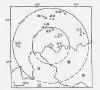 |
图1 金平5.5级地震震中附近测震台网分布图
Fig.1 Distribution of seismometric stations
before the MS5.5
Jinping earthquake
|
|
表1 地震基本参数
Table 1 Basic parameters of the earthquake
|
编号 |
发震日期 |
发震时刻 |
震中位置 |
震级
MS |
度/km |
震中
地名 |
结果
来源 |
|
年
月
日 |
时
分
秒 |
φN |
lE |
|
1 |
1995 4 25 |
00 13 08.5 |
22°46′ |
102°44′ |
5.5 |
|
金平 |
1) |
|
2 |
1995 4 25 |
00 13 08.4 |
22°46′ |
102°44′ |
5.6 |
|
金平 |
云南地震局速报目录 |
|
3 |
1995 4 25 |
00 13 10.9 |
22°52′ |
102°59′ |
5.4 |
20 |
金平 |
BJI |
|
4 |
1995 4 25 |
00 13 09 |
22.73° |
102.90° |
5.1 |
20 |
|
ISC |
|
|
地震地质背景
据资料2),金平5.5级地震发生在红河-哀牢山深大断裂带南侧南段的藤条江断裂以西地区,其区域构造线方向以北西向为主(图2),震区北面出露三叠系陆相为主的海陆交互相碎屑夹多量中酸性火成岩组成的咱倮-黄草岭复式向斜,南面出露印支期形成的哈贡-新安寨花岗岩岩基,震区处于上述花岗岩体沿轴部侵入的昔备-骑马坝-新寨复背斜北翼的志留系浅海和海湾相泥质碎屑和碳酸盐地层中;在花岗岩体南端有一走向280°~313°的牛巩-大头活动断裂斜切入。 |
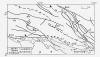 |
图2 金平附近地质构造
断裂及其他名称:①牛巩-大头断裂;②藤条江断裂;③哀牢山大断裂;
(一) 咱倮-黄草岭复式向斜;(二) 昔备-骑马坝-新寨复背斜
Fig.2 Map of geological structure around
Jinping area
|
|
金平5.5级地震等震线长轴方向北西(图3),高烈度区与茨通坝河谷走向及区域构造方向一致,震区发震构造不清楚,推测该次地震是新安寨花岗岩基沿昔备―骑马坝―新寨复背斜侵入的古老隐伏构造重新活动的结果。
据历史记载金平县地区未发生过5级以上地震。 |
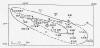 |
图3 金平5.5级地震等震线图
Fig.3 Isoseismal map of the MS5.5 Jinping
earthquake |
|
烈度分布及震害
据文献[1]和资料2),金平5.5级地震宏观震中位于金平县者米乡晖家寨与顶青之间,极震区烈度为Ⅶ度。5.5级地震Ⅶ度区呈椭圆形,长轴方向为N70°W,长13.4km,短轴长2.9km,面积约为31km2,长短轴之比为4.6∶1。其范围北至小翁邦,南到五丫果;东起晖家寨,西到顶青,区内包括12个自然村,409户,3089人(未含部队)。Ⅵ度区北起大梁;东起六八村、马家寨,西到者米拉祜族乡政府所在地,长轴方向为N70°E,长28km,短轴长6.7km,长短轴之比为4.2∶1,面积126km2,区内包括26个自然村,1050户,6711人。
综合Ⅶ度、Ⅵ度区震害的主要特征为:极震区多处出现边坡重力裂缝,公路局部滚石,个别处出现小滑坡,毛石堆砌墙混凝土屋面房屋破坏极为突出,承重墙体多出现斜裂缝、“X”裂缝及酥裂,土基或混凝土砖砌墙混凝土屋面也损坏较重;土木结构房屋,大多数墙体开裂、掉土块,少数倒塌。这次地震造成人员伤20人,无死亡;其中重伤3人轻伤17人,经济损失达1100万元人民币。 |
|
地震序列
据云南地震传输台网测定,截至1995年4月27日共发生ML≥1.2级余震17次,其中1.2~1.9级10次,2.0~2.9级7次。序列最大余震为ML2.6级,发生在5.5级地震后55小时(表2、图4)。
5.5级地震所释放能量几乎占序列总能量的100%,最大余震为ML2.6,主震与最大余震差3.6,表明金平5.5级地震为孤立型地震。
表2 金平5.5级地震序列目录(ML≥2.0)
Table 2 Catalogue of the MS5.5 Jinping
earthquake sequence ( ML≥2.0 )
|
编号 |
发震日期 |
发震时刻 |
震中位置 |
震级 |
震中
地名 |
资料
来源 |
|
年 月 日 |
时 分 秒 |
φN |
lE |
MS |
ML |
|
1 |
1995 04 25 |
00 13 08.5 |
22°46′ |
102°44′ |
5.5 |
|
金平 |
1) |
|
2 |
1995 04 25 |
06 47 31 |
|
|
|
2.1 |
|
|
|
3 |
1995 04 25 |
16 39 52 |
|
|
|
2.2 |
|
|
|
4 |
1995 04 25 |
22 16 50 |
|
|
|
2.2 |
|
|
|
5 |
1995 04 26 |
01 03 19 |
|
|
|
2.0 |
|
|
|
6 |
1995 04 26 |
14 45 55 |
22°48′ |
102°48′ |
|
2.2 |
|
|
|
7 |
1995 04 27 |
07 02 50 |
22°42′ |
102°49′ |
1.9 |
2.6 |
|
|
|
8 |
1995 04 27 |
22 06 14 |
22°46′ |
102°46′ |
|
2.2 |
|
|
由序列M-t图(图4)可见,5.5级地震后无ML≥3.0级地震,余震强度显著偏低,b值为0.94(图5),显高值异常,p值为1.08(图6),序列衰减较快,h值为1.6(图7)。 |
 |
图4 金平5.5级地震序列M-t图
Fig.4 M-t diagram of the MS5.5 Jinping
earthquake sequence
(ML≥1.0)
|
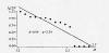 |
图5 金平5.5级地震序列b值图
Fig.5 b-value diagram of the MS5.5 Jinping
earthquake sequence
(ML≥1.2)
|
 |
图6 金平5.5级地震序列N-t日频度曲线
Fig.6 N-t curve of the MS5.5 Jinping
earthquake sequence (ML≥1.2)
|
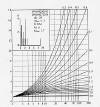 |
图7 金平5.5级地震序列h值图
Fig.7 h-value diagram of the MS5.5 Jinping
earthquake sequence
(ML≥1.2)
|
|
由地震序列震中分布图(图8)可见,地震微观震中与宏观震中相距10km。余震活动集中分布在微、宏观震中之间的北北西向条带上,余震区长约10km,宽约9km,面积约70km2。 |
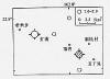 |
图8 金平5.5级地震余震震中分布图
Fig.8 Epicentral distribution of the MS5.5
Jinping
earthquake sequence
|
|
震源机制解及地震主破裂面
应用P波初动符号图解断层面法,收集云南省地震台网初动符号19个获得的金平
5.5级地震震源机制解(矛盾符号比为0.105),结果见表3和图9。 |
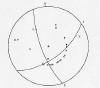 |
图9 金平5.5级地震震源机制解
Fig.9 Focal mechanism solution of the MS5.5
Jinping earthquake
|
|
表3 金平5.5级地震震源机制解
Table 3 Focal mechanism solution of the
MS5.5 Jinping earthquake
|
编
号 |
节面Ⅰ |
节面Ⅱ |
P轴 |
T轴 |
B轴 |
X轴 |
Y轴 |
结果
来源 |
|
走向 |
倾向 |
倾角 |
走向 |
|
倾角 |
方位 |
仰角 |
方位 |
仰角 |
方位 |
仰角 |
方位 |
仰角 |
方位 |
仰角 |
|
1 |
66 |
NW |
55 |
343 |
NEE |
70 |
283 |
|
27 |
40 |
187 |
48 |
73 |
20 |
329 |
35 |
王绍晋 |
由图9和表3可见,节面Ⅱ方位343°,走向NNW,倾向NEE,倾角70°,为左旋走滑断层,主压应力P轴方位283°,为NW向。
地震地质考察认为3),极震区所在区域为红河-哀牢山深大断裂带南侧南段的藤条江断裂以西地区,其区域构造线方向以北西向为主,与节面Ⅱ走向一致,极震区烈度等震线和余震区长轴方向均为北西向。综上所述,认为节面Ⅱ是地震的主破裂面,其走向与极震区的断裂一致,金平地震是在北西向主压应力作用下,北北西向断层面发生左旋走滑错动的结果。 |
|
观测台网及前兆异常
图1和图10为震中附近地区测震台站和定点前兆观测台站分布图,地震发生在前兆观测台站相对稀疏的地区。 |
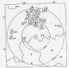 |
图10 金平地震前定点前兆观测台站的分布图
Fig.10 Distribution of precursory monitoring
stations before
the MS5.5 Jinping earthquake
|
|
金平5.5级地震震中周围200km范围内共有地震台站16个,其中开展测震观测台9个,定点前兆观测台站15个,有水位、水氡、水汞、地温、地倾斜、短水准、短基线、地电、地磁等11个观测项目共42个台项,这些前兆观测项目大多数均有3年以上连续可靠的观测资料。在0~100km和101~200km范围内分别有测震台3个和6个,定点前兆观测台站3个和12个,测震学以外的观测项目6个和11个。这次地震前共出现6个项目10条异常,其中地震活动性出现了2个项目4条异常,它们是地震频度和b值;定点前兆观测出现了4台项6条异常(图11),它们是水氡、水位、地电阻率、地倾斜;无宏观异常出现。各类异常的具体情况详见表4和图12~22。 |
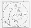 |
图11 金平5.5级地震定点前兆观测异常分布图
Fig.11 Distribution of precursory anomalies
of the MS5.5 Jinping
earthquake on the fixed observation
points
|
|
表4 异常情况登记表
Table 4 Summmary table of precursory anomalies
表4中所列各类异常、历史对应率及其预测效能简述如下:
(1)
地震活动性项目:地震活动性资料1980年至今,历史上多次对应本区及其邻近地区MS≥5级地震,预测效能较好。
(2)
定点前兆观测项目资料起始情况:水位1982年至今,水氡1990年至今,地倾斜1984年至今,地应力1989年至今,地电阻率1974年至今;上述各手段历史上多次对应本区及其邻近地区MS≥5级地震,预测效能较好。 |
 |
图12 滇南地区ML2.5~4.9级地震月频度曲线图
Fig.12 Curve of monthly frequency for the
ML2.5―4.9 earthquakes
in the south part of Yunnan province
|
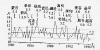 |
图13 震中周围ML2.5~4.5级地震月频度曲线
Fig.13 Curve of monthly frequency for the
ML2.5―4.5 earthquakes
around the epicentral area
|
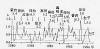 |
图14 滇南地区ML2.5~4.9级地震月b值曲线图
Fig.14 b-value curve of the ML2.5―4.9
earthquakes in the south
part of Yunnan province
|
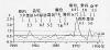 |
图15 震中周围ML2.5~4.5级地震月b值曲线
Fig.15 b-value curve of the ML2.5―4.9
earthquakes around
the epicentral area
|
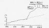 |
图16 个旧石英倾斜仪日均值
Fig.16 Curve of daily mean value of
quartzose clinometer
in Gejiu station
|
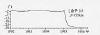 |
图17 通海石英倾斜仪日均值曲线
Fig.17 Curve of daily mean value of
quartzose clinometer in
Tonghai station
|
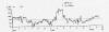 |
图18 通海电阻率南北向日均值曲线
Fig.18 Curve of daily mean value of apparent
resistivity (NS)
in Tonghai station
|
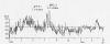 |
图19 元江水氡日均值曲线
Fig.19 Curve of daily mean value of radon
content in groundwater
in Yuanjiang station
|
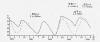 |
图20 个旧水位月均值曲线
Fig.20 Curve of monthy mean value of water
level in Gejiu station
|
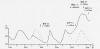 |
图21 开远水位月均值曲线
Fig.21 Curve of monthy mean value of water
level in
Kaiyuan station |
总结与讨论
通过研究金平5.5级地震的震例,我们得出以下的认识供讨论:
(1)
金平5.5级地震是发生在红河-哀牢山深大断裂带的南侧南段的藤条江断裂以西地区的一次孤立型地震,金平县为历史上无5级以上地震发生的地区。在地震发生后3个月内,与其相距
385km的孟连于1995年7月12日发生了一次7.3级地震,金平地震前定点前兆观测出现明显的中期异常、异常项目多而变幅大以及地震活动性异常的大幅度变化,可能是孟连7.3级强地震孕育过程所造成的,表明了区域应力场的强势活动特征。
(2)
震前短期异常突变均出现于金平5.5级地震前3个月左右,即震前出现了几乎同步的定点前兆观测和地震活动性的短期异常,是本次地震短期阶段异常最显著的特征。
(3) 个旧台的水位与地倾斜均出现了明显的中期异常变化,而个旧台距金平地震80
km,为前兆观测异常台站中距震中最近的,表明金平地震前中期异常台站较接近震中区,这为应用定点前兆观测异常资料对未来强震发生地点的圈定提供了一项参考性依据。
参
考 文 献
[1] 闵子群,云贵地区地震等震线图集,地震研究,23,增刊,2000。
[2]
罗平等,云南地区地震预报判据和指标研究,地震预报方法实用化研究文集(综合预报专辑),北京:地震出版社,1991。
参 考 资 料
1)云南省地震局,云南地震目录(1994~1996年),1998(铅印本)。
2)吴伯黔,1995年4月25日金平5.6级地震考察,地震通讯,4,39~41,1995。
3)云南省地震局,关于金平5.6级地震震害损失评估结果的报告,1995。
|