|
1993年12月1日新疆维吾尔自治区疏附县发生6.2地震,宏观震中为:39°18′N,
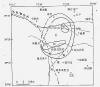
75°39′E。地震区主要分布于喀什地区疏附县和克孜勒苏柯尔克孜自治州阿克陶县的喀热克其克乡及克州种羊场。震中烈度Ⅶ度,极震区等震线方向与构造线方向有差别,其主要原因是场地条件的影响,极震区形状与盖孜河阶地一致,呈北东东向。此外,另一处Ⅶ度异常区在站敏乡西部,是卡兹克阿尔特断裂―库玛塔格山北隐伏断裂加重震害效应的结果。该次地震的发震构造为卡兹克阿尔特断裂。此次地震使喀什地区疏附县和克孜勒苏柯尔克孜自治州阿克陶县所辖5个乡(镇)的51个大队与5个直属场遭受不同程度的破坏和损失,并造成2人死亡、8人重伤、29人轻伤。毁坏的房屋面积约63
107m2,中等和严重破坏的房屋面积约为364
673m2。直接经济损失5 931万元(含5.8级强余震损失)。
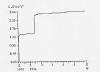
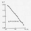
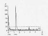
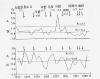
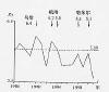
疏附6.2级地震序列最大余震发生之前,序列衰减缓慢,之后则迅速衰减,其p值为1.4。地震序列类型介于主震-余震型和震群型之间。截止1994年5月底共发生ML≥2.0级地震725次。3级以上余震分布大致呈北北东向,震源机制的节面Ⅰ走向北西,与构造走向一致。P轴方位78°,仰角20°,由此推测本次地震是在北东东向主压应力作用下断裂发生左旋走滑错动的结果,节面Ⅰ是地震的主破裂面。
震中附近300km范围内有喀什、阿图什、乌恰、塔什库尔干、巴楚和阿合奇地震台,其中喀什台有测震和地磁、阿合奇台有测震和地倾斜两个观测项目,其他各台只有测震一个观测项目。
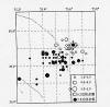
震前共出现异常6条,全部为地震活动性异常,在这次地震之前,新疆地震局作出了一定程度的预测。
Abstract
An
earthquake of MS 6.2 occurred in Shufu county of
Xinjiang Uygur Autonomous Region on Dec. 1, 1993 with its
macroseismic epicenter at 39°18′N,75°39′E.
The seismic region was located in Shufu county of Kashi and the
Karekeqike town in Aketao county and the stud sheep farm in Kezilesu
Kerkezi autonomous prefecture. The epicentral intensity is Ⅶ
and isoseismal lines in the meizoseismal area are
different from the tectonic lines because of the effect of the
terrain conditions, i.e., the shape of meizoseismal area is the same
as the Gaizi River terrace in NEE direction. In addition, another
area of intensity Ⅶ is in the west of
Zhanmin town of the intensified the earthquake disaster result of
the Kazikeaerte fault, the hidden fault of the Northern Kumatage
Mount. The seismogenic structure is located on the Kazikeaerte
fault.
The
earthquake caused damage and losses in different degrees in Shufu
county of Kashi, 51 production brigades in 5 towns and 5 farms in
Aketao county of Kezilesu Kerkezi autonomous prefecture. The
earthquake killed 2 people, injured 8 people severely and 29 people
slightly. Houses of about 63,107 square meters were destroyed, and
houses of about 364,673 m2 were damaged in medium degree
or severely. The direct economic loss was 59.31 million yuan RMB
(including the loss caused by the MS5.8 strong
aftershock).
The
seismic sequence of the Shufu MS6.2 earthquake
decayed slowly before the maximum aftershock, and then it decayed
rapidly. Its P value is 1.4, and the sequence type was between
mainshock- aftershock and earthquake swarm. There were 725
earthquakes of ML≥2.0
by the end of May,1994. The aftershocks of ML≥3.0
distributed mainly in NNE direction, the nodal plane I in the focal
mechanism solution stroke in NW direction which was the same as the
strike of the tectonic structures. The P axis azimuth was 78°and
the dip angle was 20°. It is suggested
that the earthquake was caused by the left-lateral strike-slip
displacement under the action of the main compressive stress in NEE
direction and the nodal planeⅠwas the
main fracture surface.
There
were seismic stations at Kashi, Atushi, Wuqia, Tashikuergan, Bachu
and Aheqi within the distance of 300km from the epicenter. There
were seismometric and geomagnetism observation items at the Kashi
station, and seismometric and ground tilt observations at the Aheqi
station but only seismometric observation at other stations.
There
were 6 anomalies before the earthquake and all of them were
anomalies of seismic activity. The Seismological Bureau of Xinjiang
Uygur Autonomous Region made a forecast in certain degree before the
event.
|