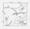
宁河6.9级地震是唐山地震的强余震,属于唐山地震序列。作为宁河余震区,宁河6.9级地震释放的能量约占本区释放的全部能量的82%[3]。宁河余震区的余震应变释放、频度衰减起伏较大,b值偏低。图3为宁河地区余震M-t图。宁河 6.9级和6.3级地震后余震分布如图4。宁河余震区的余震频度衰减如图5,频度衰减系数p值为1.08[3]。 |
 |
图3 宁河地区余震的M-t图 (ML≥4.0)
Fig.3 M-t diagram for the aftershock sequence in Ninghe region
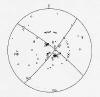
范围: 北纬―39°05′-39°40′, 东经―117°30′-118°20′
|
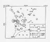 |
图4 宁河6.9和6.3级地震余震震中分布图[3](ML≥3.0)
Fig.4 Epicentral distribution of aftershocks of the M6.9, M6.3 Ninghe
earthquakes
|
如果把宁河地震作为次一级的序列看待,表2列出了宁河6.9级地震后的余震月频度,表3为月释放地震波能量,而图6则为地震波能量衰减曲线。 |
 |
图5 宁河余震区的余震频度衰减曲线[3] (1976.7.28--1979.12.31;ML≥2.5)
Fig.5 Frequency attenuation of aftershocks of the Ninghe earthquake
|
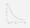 |
图6 宁河6.9级地震序列能量衰减曲线
Fig.6 Energy attenuation curve for the M6.9 Ninghe earthquake sequence
|
表2 宁河6.9级地震后的余震月频度
Table 2 Monthly frequency of aftershocks of the Ninghe M6.9 earthquake
序号 |
日 期 |
地震次数(ML≥2.0) |
备 注 |
1 |
1976.11.16-12.15 |
18 |
范围同图3
|
2 |
1976.12.16-1977. 1.15 |
8 |
3 |
1977. 1.16-2.15 |
4 |
4 |
1977. 2.16-3.15 |
1 |
5 |
1977. 3.16-4.15 |
5 |
6 |
1977. 4.16-5.15 |
6 |
7 |
1977. 5.16-6.15 |
6 |
8 |
1977. 6.16-7.15 |
3 |
9 |
1977. 7.16-8.15 |
2 |
10 |
1977. 8.16-9.15 |
4 |
11 |
1977. 9.16-10.15 |
5 |
12 |
1977.10 .16-11.15 |
2 |
13 |
1977.11 .16-12.15 |
2 |
表3 宁河6.9级地震序列月释放地震波能量
Table 3 Seismic-wave energy released month by month by the M6.9 Ninghe earthquake sequence
年.月 |
1976.11 |
1976.12 |
1977.1 |
1977.2 |
1977.3 |
1977.4 |
能量 (J) |
1.41×10¹⁵ |
1.12×10¹³ |
2.82×10¹² |
5.27×10¹⁰ |
7.60×10¹⁰ |
8.92×10¹⁰ |
|
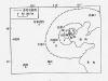
在距宁河6.9级地震震中300km范围内有前兆观测台站49个,其中测震台14个,其他前兆观测69个台项。震前有异常的12个台项,占17%。台站分布如图10。
从6.9、6.3和5.5级三次地震的统计情况看,异常主要集中在200km范围内。在定点观测项目中,异常项目(不包括测震)所占比例分别为:18%、6%、22%。
表5-7为宁河三次地震的异常情况登记表,图11-13为三次地震前的异常分布图(不包括测震学前兆),图14-46为前兆异常图。
表 5 宁河6.9级地震异常情况登记表
Table 5 Bbnormal situations of the M6.9 Ninghe earthquake
表 6 宁河6.3级地震异常情况登记表
Table 6 Bbuormal situatious of the M6.3 Ninghe earthquake
表 7 宁河5.5级地震异常情况登记表
Table 7 Bbnormal situations of the M5.5 Ninghe earthquake
|
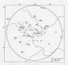 |
图10 宁河6.9级地震前台站分布图
Fig.10 Distribution of seismic stations before the M6.9 Ninghe
earthquake
|
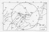 |
图11 宁河6.9级地震前的异常分布图
Fig.11 Distribution of anomalies before the M6.9 Ninghe earthquake
|
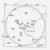 |
图12 宁河6.3级地震前的异常分布图
Fig.12 Distribueion anomalies before the M6.3 Ninghe earthquake
|
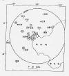 |
图13 宁河5.5级地震前的异常分布图
Fig.13 Distribution anomalies before the M5.5 Ninghe earthquake
|
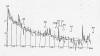 |
图14 邢台地震群月频度变化与华北地震的关系3)
Fig.14 Relation between the variation of monthly frequency of
Xingtai seismic swarm and earthquakes of North China
|
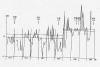 |
图15 林县小震月频度变化与附近较大地震的关系3)
Fig.15 Relation between the variation of monthly frequency of
Linxian small earthquakes and the larger earthquakes
surrounding linxian
|
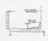 |
图16 宁河�l口井6.9级地震的临震及震时突变水位曲线[3]
Fig.16 Curve for imminent and coseismic change of water level in
Biaokou well at Ninghe during the M6.9 earthquake
|
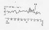 |
图17 塘沽井水氡日值曲线3)
Fig.17 Curve for daily mean values of radon content in water at
Tanggu well
|
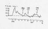 |
图18 津2热水井的CO2含量五日均值曲线[3]
Fig.18 Curve for 5-day mean values of CO2 content in water at
Tianjin thermal well
|
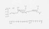 |
图19 宝坻台视电阻率五日均值曲线3)
Fig.19 Curve for 5-day mean values of apparent resistivity in
Baodi station
|
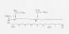 |
图20 遵化温泉流量变化曲线[3]
Fig.20 Curve for flux variation of Zunhua spring
|
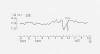 |
图21 徐庄子台视电阻率五日均值曲线3)
Fig.21 Curve for 5-day mean values of apparent resistivity in
Xuzhuangzi station
|
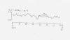 |
图22 廊坊火车站水氡自记值3)
Fig.22 Recording value of radon content in water at Langfang
railway station
|
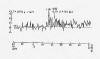 |
图23 北京管庄水氡瞬时值曲线3)
Fig.23 Curve for instantaneous value of radon content in water in
Guanzhuang, Beijing
|
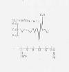 |
图24 兴济水氡日值曲线3)
Fig.24 Daily value curve for radon content in water in Xingji
|
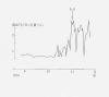 |
图25 北京万泉庄逸出气CO2含量变化曲线3)
Fig.25 Variation of the spilling gas contented with CO2 in
Wanquanzhuang, Beijing
|
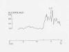 |
图26 北京光华厂热水井溶解氢含量变化曲线3)
Fig.26 Variation curve for dissolved hydrogen content of thermal
well at Guanghua factory, Beijing
|
 |
图27 雄县水氡日值曲线3)
Fig.27 Daily value curve for radon content in water in Xiongxian
|
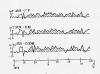 |
图28 地磁日幅差变化量3)
Fig.28 Variations of daily amplitude differences of geomagnetism
|
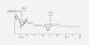 |
图29 渤海油田某油井油产量变化曲线[3]
Fig.29 Curve for change of the production in an oil well at Bohai
oil field
|
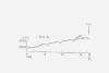 |
图30 锦州应力(电感)变化曲线3)
Fig.30 Curve for crustal stress by electro-magnetic element in
Jinzhou station
|
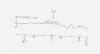 |
图31 廊坊水氡日值曲线3)
Fig.31 Daily value curve for radon content in water in Langfang
|
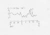 |
图32 北京海淀菜站浅井逸出氡浓度的变化[3]
Fig.32 Variation of radon relaesed from shallow well of Haidian
food market, Beijing
|
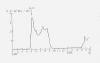 |
图33 兴济水氡日值曲线3)
Fig.33 Daily value curve for radon content in water in Xingji
|
 |
图34 地磁日幅差变化量3)
Fig.34 Variations of daily amplitude differences of geomagnetism
|
 |
图35 唐山地震序列频度曲线3)
Fig.35 Frequency curve for the Tangshan earthquake sequence
ML≥3.0级,15天累计,日滑动
|
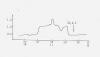 |
图36 唐山地震序列滑动b值曲线3)
Fig.36 Slip b-value curve for the Tangshan earthquake sequence
|
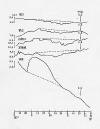 |
图37 宁河5.5级地震地下水位异常变化3)
Fig.37 Abnormal change of ground water level of the M5.5 Ninghe
earthquake
|
 |
图38 水氡日值曲线临震突跳变化3)
Fig.38 Daily value curve for radon content in water with imminent
change before the earthquake
(a) 芦台农场 ; (b) 塘沽 ; (c) 兴济
|
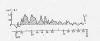 |
图39 津2井CO2 (色谱)日值曲线3)
Fig.39 Daily value curve for CO2 (Chromatogram) in No.2 well,
Tianjin
|
 |
图40 津2井气体总量(吸收法)日值曲线3)
Fig.40 Curve for daily mean values of the total of the gas
(absorption) in No.2 well, Tianjin
|
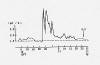 |
图41 津棉4井CO2(色谱)日值曲线3)
Fig.41 Daily value curve for CO2 (Chromatogram) in the well of
No.4 cotton-mill in Tianjin
|
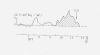 |
图42 蓟50井水氡五日均值曲线3)
Fig.42 Curve for 5-day mean values of radon content in water in
Jixian No.50 well
|
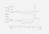 |
图43 宝坻台视电阻率五日均值曲线3)
Fig.43 Curve for 5-day mean values of apparent resistivity in
Baodi station
|
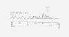 |
图44 河西务1井水氡日值曲线3)
Fig.44 Daily value curve for radon content in water in the Hexiwu
No.1 well
|
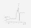 |
图45 昌黎应力电感日均值曲线3)
Fig.45 Daily value curve for crustal stress by electro-magnetic
element in Changli station
|
 |
图46 地磁日幅差变化量3)
Fig.46 Variations of daily amplitude differences of geomagnetism
|